IMD forecasts near-normal monsoon rainfall for Northeast India in 2026 despite a likely weak monsoon across India due to emerging El Niño conditions.
Imphal, May 29: Even as the India Meteorological Department (IMD) has warned that India may experience a below-normal southwest monsoon in 2026, the outlook for Northeast India appears relatively more stable, with most northeastern states likely to receive near-normal rainfall during the June–September monsoon season.
The updated long-range forecast released by the Ministry of Earth Sciences on Thursday projected national monsoon rainfall at 90% of the Long Period Average (LPA), placing the country in the “below normal” category.
However, the Northeast region stands apart from much of mainland India. IMD’s regional forecast table shows Northeast India carrying nearly balanced probabilities across below-normal, normal and above-normal rainfall categories, with the highest probability lying in the “normal rainfall” range of 94–106% of LPA.
The maps accompanying the report further suggest that while large parts of central, western and peninsular India may struggle with rainfall deficits and rising heat, the Northeast could continue receiving active monsoon moisture flow through June and much of the season.
The forecast comes amid signs that neutral Pacific Ocean conditions are transitioning towards El Niño, a climate pattern often associated with weaker Indian monsoons.
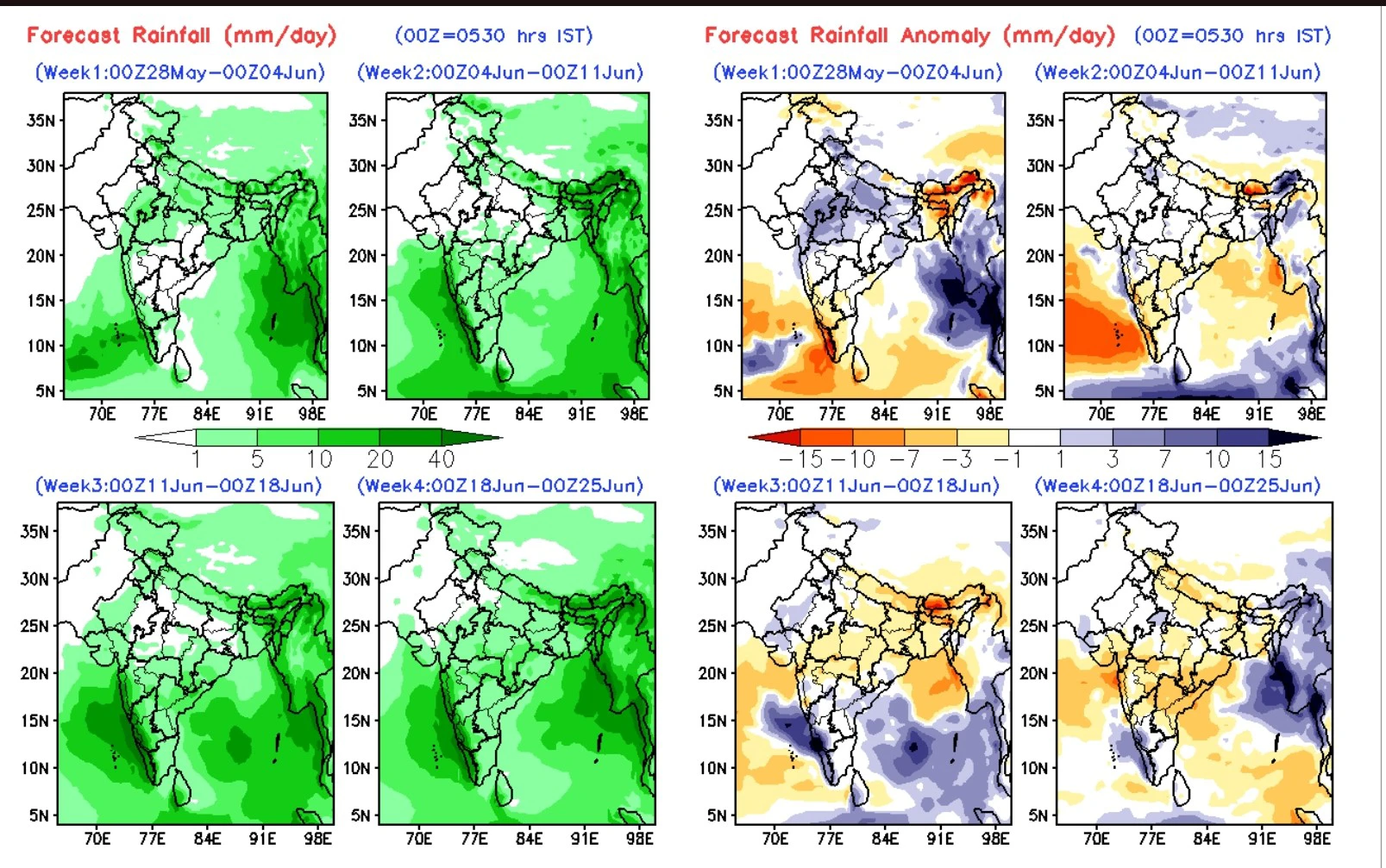
Rainfall Maps
Across much of mainland India, especially central India and the Gangetic plains, yellow and orange dominate, indicating rainfall deficits.
By contrast, Northeast India shows substantial green and blue zones, particularly over Arunachal Pradesh, Meghalaya and parts of Assam, indicating stronger monsoon support.
Rainfall Anomaly Maps
The anomaly maps show repeated blue concentrations over the Bay of Bengal and eastern Himalayan sectors through multiple forecast weeks, suggesting sustained moisture transport towards Northeast India.
Temperature Maps
For temperature anomalies, the Northeast is largely spared from the intense red heat signatures affecting northwest and central India, though warmer-than-normal nights are still expected across many northeastern states.
Heatwave Maps
Most of Northeast India remains outside the severe heatwave belt forecast for northwestern, central and eastern India. However, isolated warm spells are still possible in lowland areas.
Monsoon Winds Strengthening Towards Northeast
The low-level wind maps included in the extended-range forecast show strong southwesterly moisture flow from the Arabian Sea and Bay of Bengal towards eastern India and the Northeast through all four forecast weeks from late May to late June.
These wind vectors are particularly important because they indicate how consistently moisture may feed into the region.
The wind anomaly charts also suggest stronger-than-normal monsoon flow over parts of eastern India and the Bay of Bengal during several weekly phases, which could support sustained rainfall over Assam, Meghalaya, Arunachal Pradesh and adjoining states.
Meteorologists say this is one reason why the Northeast outlook differs from central India despite the broader weak monsoon signal nationally.
Statewise Northeast Outlook
Assam: Near-Normal Rainfall but Flood Risk Persists
Assam is likely to receive generally normal monsoon rainfall during June–September, according to the seasonal probability maps.
The weekly rainfall forecasts show active precipitation belts repeatedly covering upper Assam, central Assam and the Brahmaputra valley. The anomaly charts indicate periods of above-normal rainfall activity during parts of June, especially closer to the Meghalaya foothills and eastern Assam sectors.
This raises the possibility of localized flooding even if the season overall remains “normal.”
The Brahmaputra basin is highly sensitive to concentrated rainfall over Arunachal Pradesh and upstream Himalayan catchments. Heavy rainfall episodes in those regions can rapidly increase river discharge downstream into Assam.
The temperature outlook maps show Assam mostly under near-normal to slightly above-normal minimum temperatures during June, meaning nights may remain unusually warm and humid.
While widespread severe heatwave conditions are not forecast for Assam, western Assam districts could occasionally experience heat stress during dry spells between rainfall events.
Meghalaya: Heavy Rain Episodes Likely Despite Balanced Seasonal Forecast
Meghalaya appears within a favourable rainfall corridor in both the seasonal and June rainfall maps.
Large sections of Khasi Hills, Jaintia Hills and Garo Hills remain under green and blue probability zones, suggesting sustained monsoon activity.
However, meteorologists caution that “normal seasonal rainfall” does not necessarily mean evenly distributed rainfall.
In Meghalaya, even short-duration intense rainfall events can trigger landslides, flash floods, road blockages, and urban waterlogging.
The weekly rainfall maps suggest repeated moisture surges from the Bay of Bengal into the Meghalaya plateau during multiple weeks of June.
Temperature anomalies are expected to remain relatively moderate due to persistent cloud cover and rainfall activity.
Arunachal Pradesh: Strong Rainfall Signals, Landslide Concerns
Arunachal Pradesh emerges as one of the strongest rainfall zones in the Northeast forecast maps.
Several parts of the state fall within blue-shaded probability areas indicating above-normal rainfall tendencies.
The eastern Himalayan topography enhances rainfall whenever strong monsoon currents strike the mountain slopes. This may benefit hydropower reservoirs and river recharge systems but could also heighten disaster risks.
The state may witness landslides along mountain highways, road washouts, slope failures, and swollen river systems.
Districts connected through vulnerable hill corridors, including Tawang, West Kameng, Lower Subansiri, Siang regions and eastern Arunachal sectors, may require close monitoring during active monsoon phases.
Night temperatures are also expected to remain warmer than average in several valleys.
Manipur: Stable Monsoon Outlook but High Humidity Expected
Manipur largely falls within the normal rainfall category in both the June outlook and the seasonal monsoon map.
The valley districts, including Imphal valley, may receive relatively stable monsoon progression during June and July, while the surrounding hill districts could see intermittent heavy rain episodes.
The rainfall anomaly maps show the Northeast periodically entering above-normal rainfall phases during weekly cycles, which may benefit paddy cultivation and water recharge in Manipur.
However, the minimum temperature anomaly charts suggest warmer-than-normal nights across much of the state.
This means increased humidity, uncomfortable nighttime conditions, and potential heat stress during breaks in rainfall.
Although IMD’s national heatwave map does not place Manipur inside the core heatwave zone, isolated hot and humid spells are still possible in valley areas before full monsoon stabilization.
The low-level wind charts also show sustained moisture transport towards Northeast India through June, which supports the possibility of continued rainfall activity over the state.
Mizoram: Persistent Moisture Flow May Trigger Slope Instability
Mizoram is expected to remain under active monsoon influence through much of June and the broader season.
The state lies close to strong Bay of Bengal moisture channels visible in the wind forecast maps.
Southern and western Mizoram may experience prolonged wet phases, particularly during periods when monsoon currents intensify over Bangladesh and adjoining Northeast India.
The combination of steep terrain and saturated soil conditions increases the possibility of landslides, mudslides, road damage, and disruptions in remote hill districts.
Temperatures are likely to remain moderate because of cloud cover and persistent rainfall activity.
Nagaland: Mixed Rainfall Distribution Possible
Nagaland’s rainfall outlook appears generally normal, though the maps indicate some spatial variability between western and eastern sectors.
The state may experience alternating wet and relatively drier periods depending on the positioning of monsoon troughs over eastern India.
The minimum temperature outlook indicates warmer-than-average nights across parts of Nagaland during June.
While widespread heatwave conditions are unlikely, lowland urban centres may still witness humid discomfort during weak rainfall periods.
Tripura: Moisture-Rich Conditions Likely Through June
Tripura falls within a relatively moisture-rich monsoon zone in the IMD outlook.
The weekly rainfall forecasts indicate repeated precipitation support from Bay of Bengal systems moving northeastward.
Because of its location near Bangladesh and the eastern Bay moisture corridor, Tripura may receive active rainfall spells during June and July.
Localized flooding and waterlogging may occur during intense rainfall bursts, particularly in low-lying districts.
Although the state remains outside India’s major heatwave belt, humidity levels are likely to rise substantially.
Sikkim: Intense Rainfall Episodes Possible
Sikkim’s eastern Himalayan location places it under strong monsoon influence in the forecast maps.
The state may witness frequent heavy rainfall spells, particularly along Teesta basin catchments.
Authorities may need to monitor landslides, glacial-fed river surges, road connectivity disruptions, and hill slope erosion.
Cloud cover and rainfall are likely to keep daytime temperatures relatively moderate, although nighttime temperatures may remain above average.
Heatwave Outlook: Northeast Largely Safer Than Mainland India
One of the more significant findings from the IMD report is that Northeast India remains largely outside the major heatwave danger zone forecast for June 2026.
The heatwave anomaly map shows the most severe heatwave expansion concentrated over Uttar Pradesh, Bihar, Punjab, Haryana, Odisha, Chhattisgarh, Gujarat, and parts of Andhra Pradesh.
By contrast, Northeast India mostly falls in neutral or below-normal heatwave probability zones.
Still, IMD’s temperature outlook suggests many northeastern states may experience warmer nights, increased humidity, reduced nighttime cooling, and intermittent hot spells before rainfall intensifies.
Urban centres such as Guwahati, Agartala and Imphal could see discomfort levels rise sharply during humid stagnant periods.
El Niño Remains the Biggest Uncertainty
The IMD noted that the Pacific Ocean is gradually transitioning towards El Niño conditions, which historically weaken Indian monsoon circulation.
However, Northeast India often behaves differently from central and western India because of its direct exposure to Bay of Bengal moisture channels and Himalayan topography.
Meteorologists say the final outcome will depend on Bay of Bengal low-pressure systems, monsoon trough positioning, local mountain circulation, and the strength of El Niño development during July and August.
Agriculture Outlook for Northeast India
The forecast may offer cautious optimism for rain-fed agriculture across the Northeast.
Paddy cultivation, horticulture and river-fed farming systems may benefit if rainfall remains near-normal.
However, experts warn that climate variability increasingly causes rainfall concentration into shorter high-intensity events rather than evenly distributed rainfall.
This means floods, landslides, crop damage, and drainage stress can still occur even during a “normal” monsoon year.
The IMD said it will release the July rainfall forecast in the last week of June.