Heavy rainfall is forecast across Manipur and the Northeast over the next two weeks, even as the region remains 39% below normal rainfall and faces emerging El Niño concerns.
Imphal, June 12: The southwest monsoon has fully covered all Northeastern states, but the region enters the core monsoon period facing an unusual combination of widespread rain forecasts and a significant seasonal rainfall deficit, according to the India Meteorological Department's (IMD) latest extended range forecast.
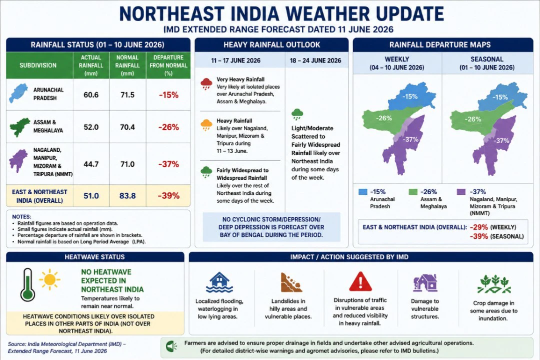
The forecast, issued on June 11, predicts continued widespread rainfall across Arunachal Pradesh, Assam, Meghalaya, Nagaland, Manipur, Mizoram and Tripura over the coming two weeks, with several states expected to experience heavy to very heavy rainfall episodes. At the same time, cumulative rainfall data show that the Northeast remains substantially below its seasonal average despite the early arrival of the monsoon.
The contrasting signals underline the complex weather pattern developing across the region as India moves deeper into the 2026 southwest monsoon season.
Monsoon establishes itself across the Northeast
According to the IMD, the southwest monsoon has already advanced across the entire Northeastern region, covering Arunachal Pradesh, Assam, Meghalaya, Nagaland, Manipur, Mizoram and Tripura. The monsoon's Bay of Bengal branch reached the region during the first phase of its advance and has remained active.
The monsoon advance map released by IMD shows that the Northeast was among the earliest mainland regions to come under monsoon influence this year. In many places, the monsoon reached close to its normal schedule, aided by strong moisture flow from the Bay of Bengal.
The region also recorded several episodes of heavy and very heavy rainfall during the week ending June 10. IMD reported heavy to very heavy rainfall at isolated locations in Arunachal Pradesh, Assam and Meghalaya, while heavy rainfall was also recorded in Nagaland, Manipur, Mizoram and Tripura.
Yet the rainfall statistics tell a more complicated story.
Northeast still 39 percent below normal
Despite frequent rain events, East and Northeast India as a whole recorded a seasonal rainfall deficit of 39 percent between June 1 and June 10. The region received 51 mm of rainfall against a normal of 83.8 mm during the period. Weekly rainfall was also 29 percent below average.
The subdivision rainfall maps included in the IMD report show that several Northeastern meteorological zones remain in deficit.
The weekly rainfall map indicates that the Nagaland-Manipur-Mizoram-Tripura subdivision recorded rainfall well below normal during the week ending June 10, while Assam and Meghalaya also remained in deficit. Arunachal Pradesh performed comparatively better but still did not register a major surplus.
The seasonal rainfall map for June 1–10 presents a similar picture. While some pockets received adequate rainfall, much of the region continues to trail normal monsoon accumulation.
Meteorologists say such a situation can occur when rainfall arrives in short, intense bursts separated by relatively dry intervals. Heavy rain events may create local flooding while seasonal totals still remain below normal.
Heavy rainfall forecast for Manipur and neighbouring states
The immediate outlook suggests that the rainfall deficit may begin narrowing over the coming days.
IMD has forecast fairly widespread to widespread rainfall over all Northeastern states throughout June 11–17. Heavy rainfall is likely over Nagaland, Manipur, Mizoram and Tripura between June 11 and June 13. Arunachal Pradesh, Assam and Meghalaya are expected to receive heavy rainfall during several days of the week, with very heavy rainfall also forecast in parts of Arunachal Pradesh, Assam and Meghalaya.
The forecast further indicates isolated thunderstorms and lightning activity across the region during much of the period.
For hill states such as Manipur, Nagaland, Mizoram and Arunachal Pradesh, heavy rainfall raises concerns about landslides, mudslides and road blockages, especially in vulnerable stretches of national highways and mountain roads.
The IMD's impact assessment warns of possible localized flooding, waterlogging in low-lying areas, disruptions to traffic, reduced visibility, damage to vulnerable structures and localized landslides in areas receiving intense rainfall.
Forecast maps point to a wetter Northeast
An examination of the rainfall forecast charts attached to the IMD report suggests that the Northeast will remain one of India's most active rainfall zones during both forecast weeks.
The rainfall distribution maps show a broad belt of moderate to heavy rainfall extending across Assam, Meghalaya, Arunachal Pradesh and adjoining hill states. Moisture-laden southwesterly winds from the Bay of Bengal are expected to continue feeding rain-bearing systems into the region.
The anomaly maps indicate that while rainfall may remain below normal across several parts of India, portions of the Northeast are likely to receive rainfall close to or above climatological averages during parts of the forecast period.
This suggests that the region could gradually recover some of its early-season deficit if forecast rainfall materializes as expected.
El Niño development emerges as a longer-term concern
Beyond the short-term forecast, one of the most important aspects of the IMD report concerns the evolving state of the Pacific Ocean.
The department noted that neutral ENSO conditions are transitioning toward El Niño conditions. According to the Monsoon Mission Climate Forecast System, El Niño may develop during the southwest monsoon season.
For Northeast India, El Niño years often bring increased rainfall variability. While some areas may continue receiving heavy rainfall episodes, others can experience prolonged dry spells between rain events.
Agriculture across the region remains heavily dependent on monsoon consistency. Farmers preparing paddy fields, especially in the valley regions of Manipur and agricultural belts of Assam and Tripura, will closely monitor rainfall patterns during the coming weeks.
IMD also reported that neutral Indian Ocean Dipole conditions currently prevail and that weak positive IOD conditions may emerge later in the monsoon season. Such conditions can sometimes offset some adverse impacts associated with El Niño.
No cyclone threat over Bay of Bengal
The forecast does not indicate the formation of any cyclone, deep depression or major low-pressure system over the Bay of Bengal during the outlook period.
Instead, rainfall over the Northeast is expected to be generated by monsoon flows, upper-air circulations and seasonal trough systems.
The absence of a cyclone threat reduces the risk of extreme wind damage, although heavy rainfall-related hazards remain significant.
Agriculture and disaster preparedness
The IMD has issued agricultural advisories for Northeastern states in view of expected heavy rainfall.
For Arunachal Pradesh, farmers have been advised to ensure proper drainage in rice nurseries and crop fields to prevent waterlogging and seedling damage. In Assam, farmers have been advised to improve drainage arrangements for rice nurseries, vegetables, banana and citrus plantations and postpone nursery sowing of Sali rice during periods of intense rainfall. Meghalaya farmers have been advised to maintain drainage channels and protect young seedlings from direct exposure to heavy rain. Tripura farmers have been advised to complete harvesting and move produce to safer locations.
The recommendations reflect the likelihood of rainfall intensity increasing during the coming week.
Critical weeks ahead for the region
For Northeast India, the next fortnight could prove decisive in shaping the early trajectory of the 2026 monsoon season.
The region has already witnessed the arrival of the monsoon and several rounds of heavy rain. Yet rainfall totals remain below normal across many areas, highlighting the uneven nature of monsoon distribution so far.
If the forecast heavy rainfall materializes, seasonal deficits may begin to narrow across parts of the region. At the same time, the risk of flash floods, landslides and localized disruptions is expected to increase, particularly in vulnerable hill districts and river catchments.
With IMD also warning of a possible transition toward El Niño conditions later in the season, weather experts will be watching closely to see whether the Northeast's monsoon remains active enough to overcome its early shortfall or whether larger climate influences begin shaping rainfall patterns in the months ahead.